Roman aqueduct: carrying water tens of kilometers only thanks to a slope of a few tens of centimeters per kilometer
Executive Briefing
Synthesized and verified with gemini-2.0-flash-thinking-exp
“Without pumps or engines, the Romans still brought clean water from streams dozens of kilometers awa”
Key Takeaways
- 1.Without pumps or engines, the Romans still brought clean water from streams dozens of kilometers away to fountains, public baths and homes in the city.
- 2.The secret is gravity: the canal is built with a continuous, steady slope, with some sections only lowering a few tens of centimeters per kilometer.
- 3.The arch-shaped aqueduct bridges that we often see in photos are just the tip of dozens of kilometers long structures, most of which run underground.
Without pumps or engines, the Romans still brought clean water from streams dozens of kilometers away to fountains, public baths and homes in the city. The secret is gravity: the canal is built with a continuous, steady slope, with some sections only lowering a few tens of centimeters per kilometer. The arch-shaped aqueduct bridges that we often see in photos are just the tip of dozens of kilometers long structures, most of which run underground.
From a fountain in the cow market
Rome's first aqueduct was the Aqua Appia, built by the procurator Appius Claudius Caecus in 312 BC. It takes water from a spring 16.4 km from the city, the entire route only drops about 10 m, and pours about 75,500 m³ of water every day into a fountain at the Forum Boarium beef market. Most of the lines run underground, which is both less costly to build and more difficult for enemies to sabotage during wartime.
By the 3rd century, Rome had 11 aqueducts with an estimated total length of 780 to 800 km, of which only about 47 km ran on arches. This amount of water feeds a city of more than a million people, most of it for public baths. Cities throughout the empire followed suit, embracing the aqueduct as a source of local pride.
Just enough slope, no more
A typical channel is about 0.7 m wide, about 1.5 m high, 0.5 to 1 m deep underground, with a probe cover for inspection and repair. Architect Vitruvius, in his 1st century BC book De architectura, advised a slope of no less than 1/4,800, a number that matches the slope measured in many remaining sewers. The steeper the slope, the faster the water flows, but the actual terrain forces the builder to calculate each section. When encountering hills, the Romans often went around the contour lines, rarely digging tunnels. When meeting a valley, they build an arch-shaped aqueduct, or in deep and wide places, they use a reverse siphon: let the water flow in a sealed lead pipe to the bottom of the valley and then rise up to the other side thanks to pressure.
To keep the slope accurate over tens of kilometers, surveyors used chorobates, a wooden stick about 6 m long with a plumb line at both ends and a water-filled trench to check the horizontal plane, similar to today's level.
Pont du Gard over the Gardon River in southern France: three levels of limestone arches 48.8 m high, water channel running on the top level
Pont du Gard: 17 m difference for 50 km
The most famous example is the aqueduct for the citadel of Nemausus, now Nîmes in southern France, built in the 1st century. The Fontaine d'Eure source near Uzès is only 17 m higher than the distribution tank at Nîmes. The distance as the crow flies is only about 20 km, but to avoid dense hills, the canal must curve around 50 km long, with an average slope of only 1/3,000. Every day it brings about 40,000 m³ of water to the city, and the water takes nearly 27 hours to travel the entire route.
The section crossing the Gardon River is Pont du Gard, a three-story aqueduct 48.8 m high, the longest remaining floor is about 275 m according to UNESCO. According to Wikipedia, the bridge was built largely without mortar or clamps, consisting of about 50,400 tons of limestone, some weighing up to 6 tons. After the 4th century, the canal was not maintained and gradually clogged with lime deposits. The bridge survived because it was used as a toll bridge for people crossing the river, and in 1985 became a UNESCO World Heritage Site.
Diagram illustrating the longitudinal section of a Roman aqueduct, from the source through underground canals, tunnels, and aqueducts to the distribution tank in the city
Divide water in order of priority
Returning to the city, water passes through the sedimentation tank and then into the distribution tank called castellum aquae, where lead or ceramic pipes with 25 standard diameters lead water to each place, with copper valves to open and close. Priority comes first to public fountains, then to public baths, and finally to the private homes of the rich who pay the fee. In 97, under emperor Nerva, Frontinus held the position of official in charge of Rome's water supply. In the De aquaeductu report, he said user fraud and staff corruption were the main causes of water loss and theft.
Advertisement
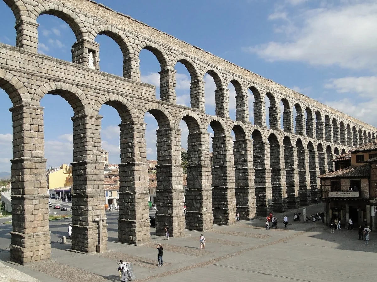
Aqueduct in the city of Segovia with a row of 167 arches, built around the end of the 1st or early 2nd century and still carrying water until 1973
Still flowing after two thousand years
Many Roman aqueducts were maintained until modern times. The Segovia Aqueduct on the Iberian Peninsula carried water until 1973. In Rome, Aqua Virgo completed by Agrippa in 19 BC, 20.5 km long but only lowered 4 m, was later restored to Acqua Vergine, and the famous Trevi fountain is the end point of this line.
Source:
Wikipedia: Roman aqueduct
,
Wikipedia: Pont du Gard
,
UNESCO: Pont du Gard
,
Wikipedia: Aqueduct of Segovia
,
Wikipedia: Aqua Virgo
,
Wikipedia: Chorobate