Do Giang Yen is more than 2,200 years old: dividing the Man River in two to control floods without dams
Executive Briefing
Synthesized and verified with gemini-2.0-flash-thinking-exp
“Most ancient irrigation works are now only ruins, but Dojiangyan in Sichuan province (China) is diff”
Key Takeaways
- 1.Most ancient irrigation works are now only ruins, but Dojiangyan in Sichuan province (China) is different.
- 2.Built by the Qin state around 256 BC, this system still regulates the Min River and irrigates about 668,700 hectares of arable land, according to UNESCO.
- 3.The special thing is that it does not block the river with a dam.
Most ancient irrigation works are now only ruins, but Dojiangyan in Sichuan province (China) is different. Built by the Qin state around 256 BC, this system still regulates the Min River and irrigates about 668,700 hectares of arable land, according to UNESCO. The special thing is that it does not block the river with a dam. The ancients divided the river according to the terrain, so that the water itself divided the flow, discharged the flood and pushed the sand and gravel away.
River from snowy mountain
The Man River is 735 km long and is a tributary upstream of the Yangtze River. In spring, melted snow water from the western mountains flows down very quickly. When it reaches the Chengdu plain, the flow slows down, and the silt settles, making the river bed shallower, so there are floods every year. During the Warring States period, the state of Qin had just occupied Shu and needed to turn this area into a food warehouse, while keeping the waterway clear for ships carrying troops. A dam across the way would block the boat's path, so the solution must be different.
According to Historical Records and Han Books, the project was commanded by Ly Bang, governor of Thuc district. There are very few records about him, and later many mythological legends were attached to his name. According to a Jin Dynasty document, he began construction around 268 BC, taking four years to build a dike to divide the water and another eight years to carve out the mountain. The article by the Chinese Heritage Project (Australian National University) notes that this is just one of the ways of telling, and some scholars believe that part of the work may have been formed much later.
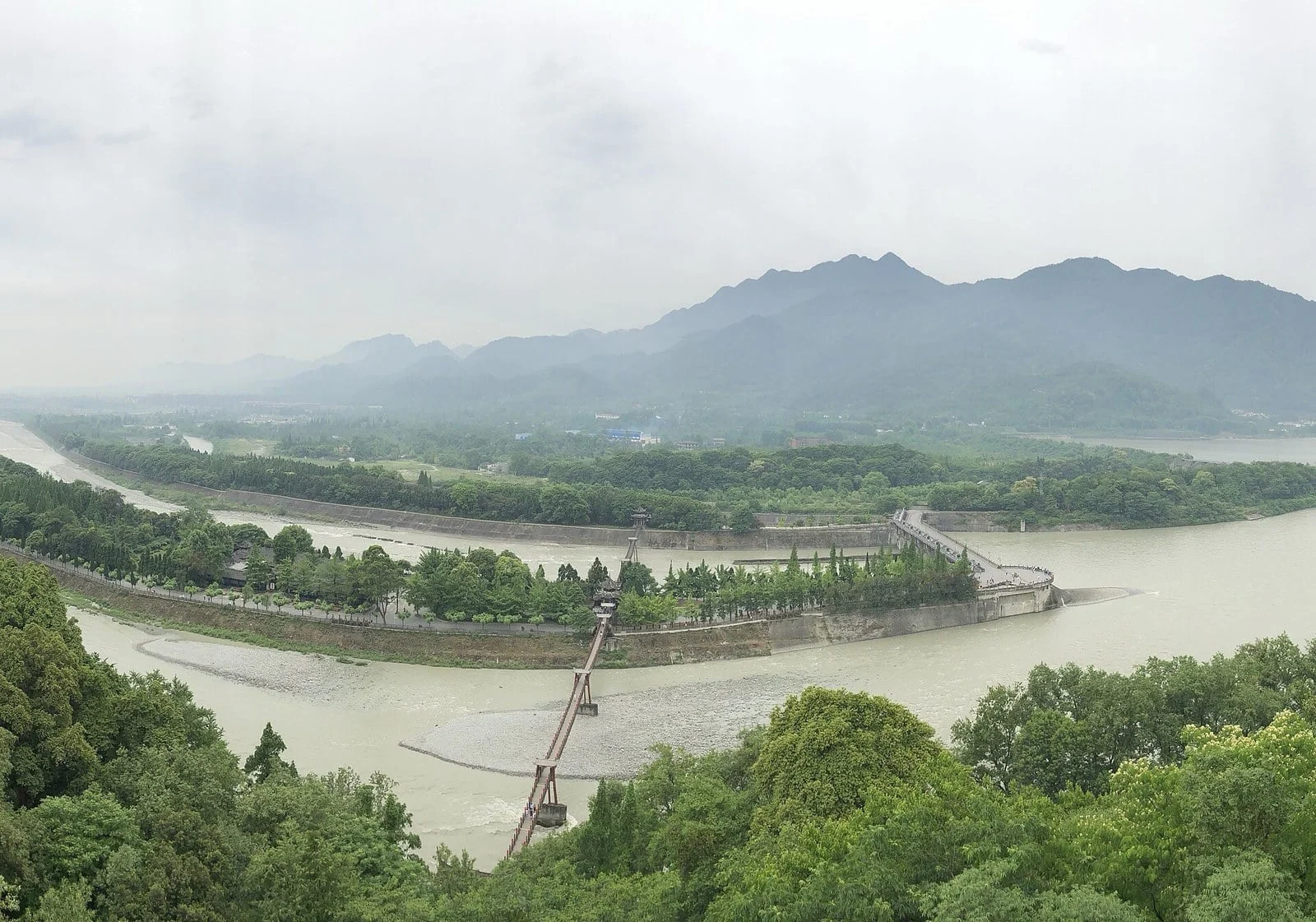
Panoramic view of Dujiangyan hub area from above: the dike strip in the middle of the river divides the Man River into two branches before the water flows into the Chengdu plain
Three projects working together
UNESCO describes the focal area as consisting of three main parts, plus auxiliary dikes and canals:
- Ngu Chuy (fish mouth): a strip of dike in the middle of the river with a sharp nose pointing upstream like a fish's mouth, dividing the Man River into a narrow and deep inner river channel for irrigation water, and a wide and shallow outer river channel to drain floods. In the dry season, thanks to the deeper bed, the inner river receives about 60% of the traffic. During the flood season, the water rises and flows into the wide branch, the portion entering the inner river is reduced to about 40%.
- Phi Sa Yen (flying sand spillway): a low bank about 200 m wide connecting the inner river with the outer river. When the water in the inner river rises, the excess flows over here, dragging sand and gravel with it. Today this dam has been rebuilt with reinforced concrete.
- Bao Binh Khau (neck vase): about 20 m wide water passage carved through Ngoc Luy mountain. The narrow gate like the neck of a vase limits the amount of water entering the plain, from there the water radiates out into the intricate network of irrigation canals.
Diagram illustrating three key works: Ngu Chuy divides water, Phi Sa Yen discharges excess water and sand and gravel, Bao Binh Khau channels water through the mountain into the irrigation canal system
Fire, water and the bend of the river
Ngu Chuy dike is covered with long bamboo baskets containing stones, held in place by wooden tripods. The hardest part is carving the mountain without explosives. According to an article by the Australian National University, if only using hammers and chisels, this could take 30 years. Ly Bang lit a fire to heat the stone and then poured cold water, causing the stone to suddenly expand and crack, making it easier to remove. The 20 m wide waterway was opened for about eight years.
The location for Ngu Chuyen was also well chosen, right at a bend. At the bend, the water on the surface rushes towards the concave bank, where the mouth of the internal river is located, while the layer of water close to the bottom carrying sand and gravel is pushed towards the convex bank, that is, the outer river. The sand that entered the inner river continued to be thrown by the vortex in front of Bao Binh Khau through Phi Sa Yen. According to documents from the Australian National University, at its most effective, the system removes up to 98% of sand and gravel.
- Bao Binh Khau, the waterway cut through Ngoc Luy mountain. The rock block with the temple on top was separated from the mountain, called Ly Doi. The gate is as narrow as the neck of a vase, limiting the amount of water flowing into the plain*
Advertisement
The secret lies in maintenance
Since Ly Bang's reign, every dry season people dredge the river bed. According to a record, he buried stone markers in the river bed in Bao Binh Khau to mark the depth that needed to be dredged: if dredging shallowly, there would be a lack of irrigation water, if dredging deeply, too much water would flow into the delta, causing flooding. The principle of "deepening the river bed, keeping the spillway low" is still applied today. A stone statue of Li Bing during the Eastern Han Dynasty was once placed in the river to measure the water level and was found in 1974.
Through the Tang, Song, Yuan, and Ming dynasties, the system was repaired and expanded. The irrigated area increased from more than 1 million acres during the Qin and Han periods to more than 10 million acres today. In 2000, Dujiangyan and Qingcheng Mountain were recognized by UNESCO as World Heritage Sites. During the Sichuan earthquake on May 12, 2008, according to UNESCO, the system was basically undamaged. In 2003, the plan to build the Duong Lieu Ho dam right at Ngu Chuy was also stopped after opposition from conservationists.
Source:
UNESCO World Heritage Center
,
China Heritage Quarterly (ANU)
,
Wikipedia: Dujiangyan
,
Wikipedia: Min River (Sichuan)