How GPS locates you: why it needs at least four satellites and an atomic clock
Executive Briefing
Synthesized and verified with gemini-2.0-flash-thinking-exp
“Open the map on your phone, a green dot appears after a few seconds.”
Key Takeaways
- 1.Open the map on your phone, a green dot appears after a few seconds.
- 2.But GPS satellites don't know where you are at all.
- 3.According to GPS.gov, the US government's information site, satellites are just lighthouses that broadcast one-way signals.
Open the map on your phone, a green dot appears after a few seconds. But GPS satellites don't know where you are at all. According to GPS.gov, the US government's information site, satellites are just lighthouses that broadcast one-way signals. All position calculations are performed by the receiver in your hand, based on a single quantity: time.
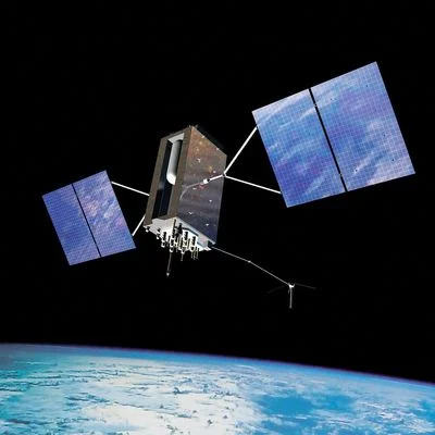
Illustration of GPS Block IIIA satellite in orbit, the latest generation of GPS satellites launched since 2018
Satellite constellation at an altitude of 20,200 km
GPS satellites fly in a medium-range orbit, about 20,200 km above the ground, each satellite orbiting the Earth twice a day. They are arranged on six equally spaced orbital planes, each with four cardinal positions, inclined about 55 degrees from the equator. This arrangement of 24 positions ensures that at least four satellites are visible from nearly every point on Earth.
The US pledges to maintain at least 24 satellites operating 95% of the time, but in reality the US Space Force regularly operates about 31 satellites. With clear skies, the receiver typically sees about nine satellites at a time.
Measuring distance with a watch
Each satellite continuously broadcasts its position and the time of the signal, according to the atomic clock located on the satellite. The receiver compares the transmit time with the receive time, multiplying the delay by the speed of light to get the distance. A signal traveling a distance of more than 20,000 km takes less than a tenth of a second, so the measurement must be extremely precise: an error of one microsecond, or one millionth of a second, is a distance of about 300 m.
So ground stations continuously monitor the satellites and send correction data, keeping the clocks on the satellites in sync to a few nanoseconds. GPS.gov says that thanks to this signal, the receiver can know the time accurately to 100 billionths of a second without needing to own an atomic clock.
Why do we need at least four satellites
If you only know the distance to a satellite, you lie somewhere on a sphere surrounding it. Two satellites narrow the position to a circle, three satellites have two points, of which one point is often located far in space so it is eliminated.
The problem lies in the clock in the receiver. The phone doesn't have an atomic clock, so any distance it measures is wrong by the same unknown amount. The receiver must solve for four unknowns: three spatial coordinates and its own clock offset. Four unknowns require four equations, or four satellites. When it sees more, the receiver uses more data to reduce errors. If an unknown is known, such as a ship's altitude of nearly 0 m, three satellites may still be enough.
Illustrative diagram: from the distance to each satellite, the receiver finds the intersection point and at the same time solves its own clock error
Relativity in pocket
The clock on the satellite is subject to two opposite effects. Satellites move quickly so clocks run slower according to special relativity, but far from Earth, where gravity is weaker, clocks run faster according to general relativity. Combined, clocks on satellites run faster than clocks on the ground by about 38 microseconds per day. In 38 microseconds, light travels about 11 km, so without compensation, the positioning results will disappear quickly.
Advertisement
Engineers handled it from the design stage: the reference frequency inside the satellite was set at 10.22999999543 MHz instead of 10.23 MHz, so that when viewed from the ground it matches the nominal value.
GPS-0012, a sample satellite used for testing of the GPS Block II generation, displayed at the San Diego Air and Space Museum (USA)
From military to civilian
- 1973: The US Department of Defense launched the project, then named it Navstar.
- 1978: Launch of the first Block I test satellite.
- 1983: after Korean Air Lines flight 007 was shot down for straying into Soviet airspace, President Ronald Reagan announced that GPS would be open for civilian use.
- 1993 - 1995: 24 satellite constellation went into operation in 1993, and in April 1995 was announced to have reached full operational capacity.
- May 1, 2000: The US turned off Selective Availability mode, which intentionally reduced the accuracy of civilian signals to an average of about 100 m.
Falcon 9 rocket put GPS III-SV09 satellite into orbit from Cape Canaveral (Florida) on January 27, 2026
Today, Wikipedia cites data showing that phones can accurately locate within about 4.9 m when combined with support services such as positioning via Wi-Fi. The new GPS III satellites transmit a fourth civilian signal L1C and are built without the Selective Availability feature, in accordance with US policy announced in 2007.
Advertisement
Thus, the blue dot on the map is the solution to a four-unknown problem, based on atomic clocks that have been adjusted according to the theory of relativity.
Source:
GPS.gov: Space Segment
,
GPS.gov: Selective Availability
,
GPS.gov: GPS and Telling Time
,
Wikipedia